Adam Scott, MS, CSCS
If you have been following our articles over the last few months you know that we are extremely interested in how our athletes (both mountain and tactical) plan for, train for, and estimate their movement over ground (MOG).
You have probably also noticed that this interest has led to a number of small research projects and studies. First there was the 5 Rules for Rucking we published last year. Then an exhaustive review of the academic literature a few months ago. These were followed by MTI studies investigating the mission direct effect of incline on speed, and, last week, a study looking at how loading effects speed.
Anyway, all of this work has been leading up to our MTI Route Card planning tool. For us, the tool is an opportunity for us to create a mission direct solution which helps athletes better estimate their time it will take them to complete a ruck, hike or mission. After all, according to US Marine Corps Reference Publication (MCRP) 3-02A:
“The standard for success of a foot march is very simple to measure: did the unit arrive at the destination at the prescribed time with the Marines in condition and required equipment present to accomplish the mission?”
Initial Results:
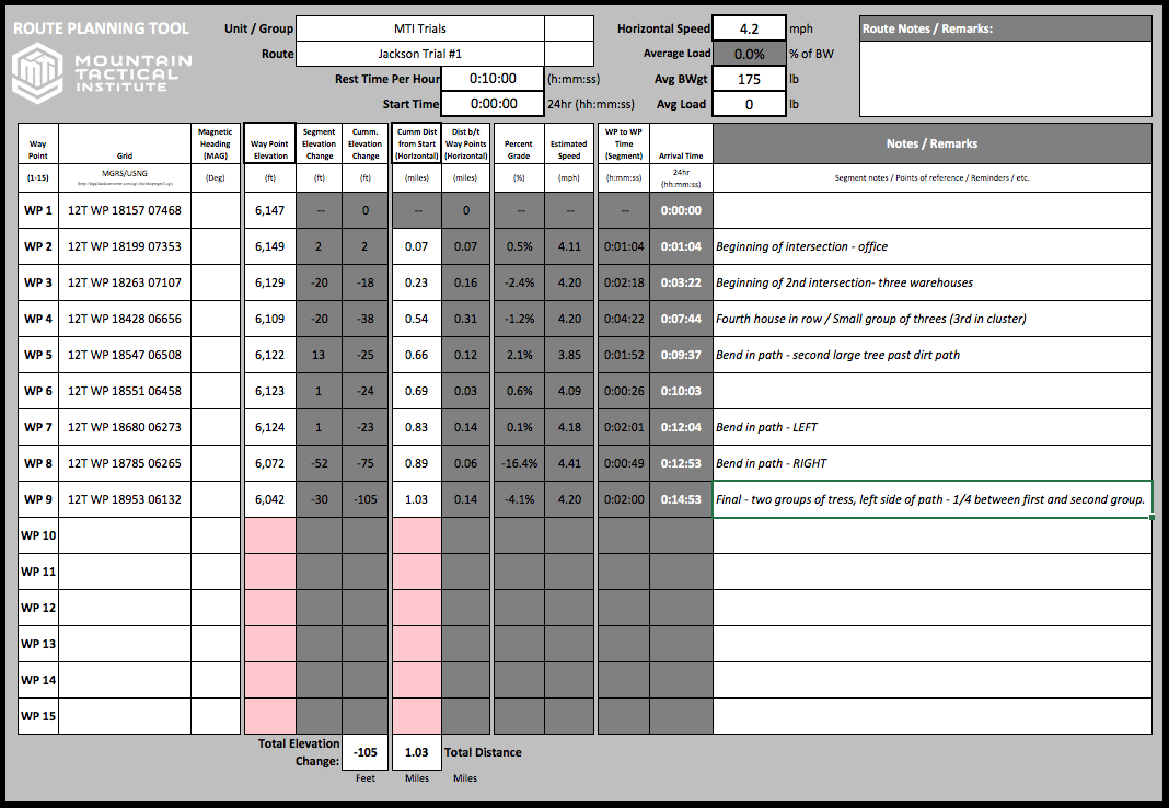
We spent most of last week taking what we learned about elevation gain, elevation loss, horizontal speed, loads, etc. and developing the algorithms which are the basis for the route card. Once we had those dialed in, we converted them into an easily adjustable excel spreadsheet. The spreadsheet was modeled after traditional military and mountain route cards. FIGURE 1 (below) shows the initial version of the MTI route card:
FIGURE 1: MTI Route Card (Example)
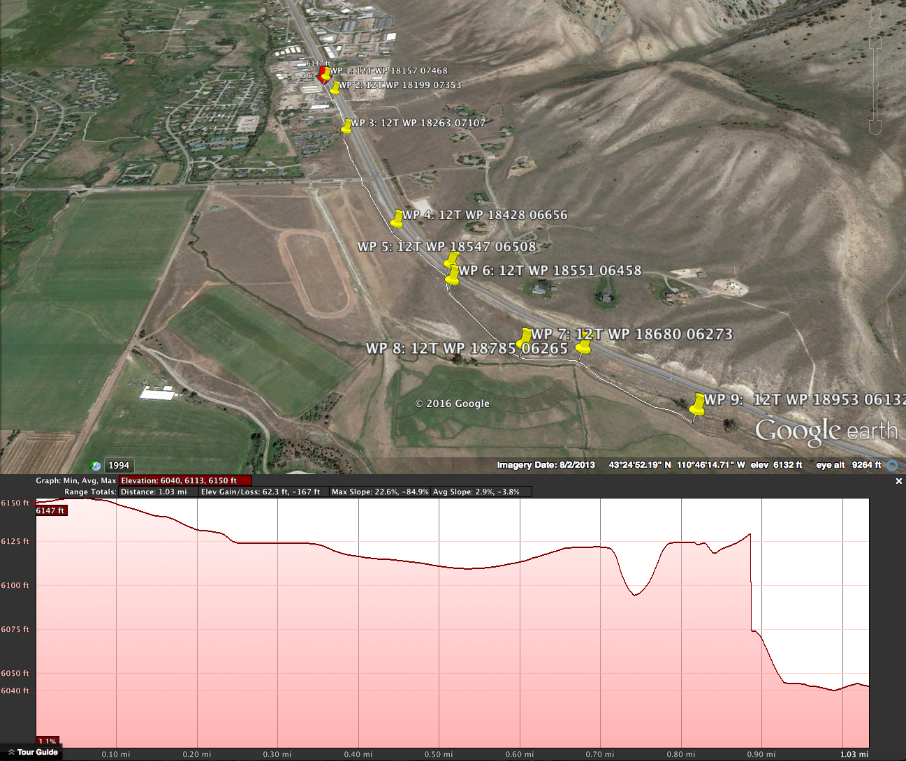
With this out of the way, it was time to start testing the route card’s predications. To do this, we first had to select a route. Using Google Earth this was easy enough:
- First, we traced a few common walking routes around Jackson, WY.
- Next, we divided the routes into easy to measure Way Points (WP).
- Then, using google earth we recorded the elevation and distance data for each WP.
Below in FIGURE 2 you can see one of the routes we tested.
FIGURE 2: Test Route via Google Maps
Next, once we had the routes mapped it was simply a matter of plugging the data into the route card. Our route card requires seven simple pieces of information in order to estimate speed and time:
- Planned Rest Intervals (example: 50 min rucking : 10 min rest)
- Start Time
- Horizontal Speed
- Body Weight (BW)
- Load Weight (LW)
- Elevations (Start, WPs and End)
- Distance
Note #1: Items 1-3 are up to the individual planning the route. Items 4 and 5 are as simple as hoping on a scale. Lastly, items 6 and 7 can be found on most maps or by using mapping software (like Google Earth).
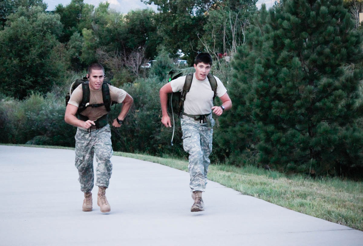
This week we were able to complete four short trials. The trails were all conducted using a planned horizontal speed of 4.2mph (brisk walk). Based on the treadmill trials we conducted last week this had our lab rats walking or rucking at HRs of between 105-115 BPM (or an RPE of 2-4 out of 10).
In this way we used HR to ensure that each trial was conducted at roughly the same overall effort (regardless of terrain and load). Using the above HR regulations the athletes then completed the route, marking their time at each way point. In order to see how accurate the route card’s predictions were all we had to do was compare the estimated times to the actual times.
Note #2: Our four trials were divided by grade and load as follows:
Our early results have been pretty promising. In TABLE 1 (below) you can see how each trial played-out. Overall we found that the first version of our route card was slightly over estimating times. Our results showed about a 3-10% deviation, this means we were off by about 1-6 minutes per hour…not bad for our first try.
TABLE 1: Estimated Route Times and Actual Route Times

Below, in GRAPH 1 you can how the route card’s estimates compared to our lab rat’s actual times during the first trial (Unloaded, Slight Uphill, 100-110 BPM).
GRAPH 1: Trial 1 – Unloaded Slight Uphill

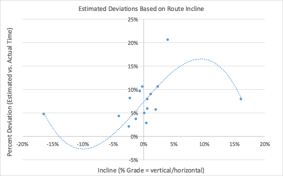
After all the trials were completed we crunched the data to see if there were any specific areas where the route card was particularly inaccurate. Below in GRAPH 2 you can see what we found. Basically the first iteration of our route card had difficulties with estimates during slight inclines (5-10%) and steeper declines (>15%)…very useful information as we tweak the card for the next version.
GRAPH 2: Deviations in Route Card Estimations by Incline/Decline
Next Steps:
Well, we are in the process of using what we learned this week to tweak our algorithms and update the route card. Our first step next week is to test the new, updated version (V2) of the route card (hopefully with another 8-10 trials). We have already mapped a wider variety of routes in order to test the boundaries of the route card. Some of these routes have inclines and declines of up to 50%. Once we have that data we will tweak the route card one more time before releasing it.
Our plan is to post the MTI Route Card as an adjustable excel workbook for anyone to use. All we ask is that users provide us with feedback on it’s accuracy so we can continue to churn the route card and improve its accuracy.
In the end we want to collect as much data as possible so that we can refine the tool to a point in which it could be used as a possible add-on to current mapping tools. Wouldn’t it be great to enter a few extra pieces of information into google earth and get an accurate estimate of how long a route should take?
Questions, comments? Please e-mail adam@mtntactical.com or rob@mtntactical.com